The future for floodplains
By Sam Olson on August 7, 2015 in Blog
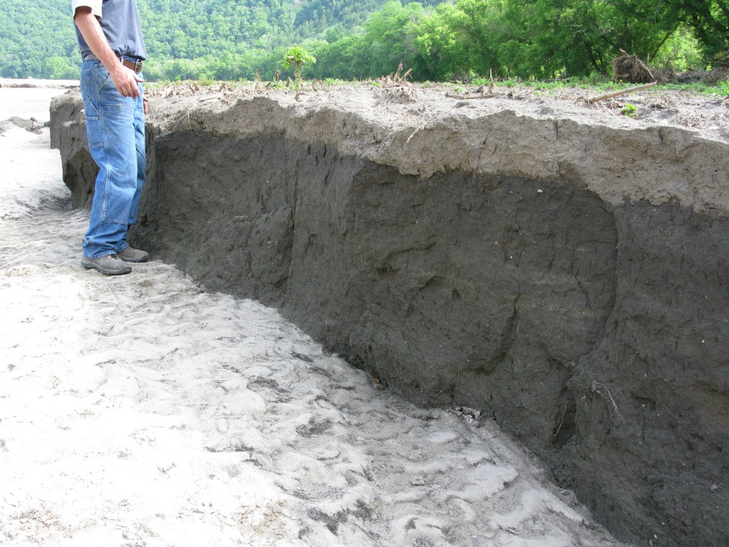
When rivers rise, the water can cut new channels in a process known as scour, which removes fertile topsoil. The damage shown above occurred on a property along the Upper Iowa River in Allamakee County.
So, what’s the deal with floodplains? Landowners with significant acres of cropland in high-risk areas on floodplains face the potential for significant crop loss and other property damage. There’s also a chance for scour, which occurs when flooded rivers begin to cut new channels, removing fertile topsoil.
What can be done? Good news! New technology has allowed mapping to predict flood risk and relative scour potential in Iowa. Since 2009, scientists at the University of Iowa Flood Center have partnered with the Iowa Department of Natural Resources to map accurately flood predication throughout the state, watershed by watershed.
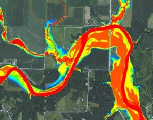
Red: 50% annual flooding probability // Orange: 20% annual flooding probability // Yellow: 10% annual flooding probability
This technology maps eight different flood return periods from a .02 percent annual probability of inundation (500-year flood) to a 50 percent annual probability (flooding half of the years, on average), in addition to mapping flood depths over the same eight return frequencies.
By comparing the force of flood waters to the ability of different USDA soil types to resist shear stress of floodwaters, the maps are able to show areas where precautions may be needed to prevent scour erosion.
Then what? There are conservation alternatives in high-risk flood areas, which can even include tax benefits for landowners.
Iowa’s floodplains are home to some of the state’s most productive and profitable cropland. Floodplains also include woodlands, pastures and flood-prone croplands that are greatly overpriced relative to the net farm income they can produce. Yet, these lands are critically important for conservation. Protecting them improves water quality, saves productive soils and creates fish and wildlife habitat for ourselves and future generations.
How can I get more information? As new county maps are sent from the Iowa Flood Center, INHF compares the highest risk areas to property records, identifying owners with a significant amount of cropland in the flood zones and inviting such landowners to educational meetings in their area. Meetings are organized in each of the mapped counties to inform landowners and officials about the risk management uses of the maps and how conservation options could be useful in managing risk.
What’s the purpose of those meetings? The meetings are most beneficial for landowners with vulnerable land in high-risk zones. County and state officials are also invited to hear about the following:
- Limitations and benefits of the technologies used by the Flood Center and the DNR to better quantify risks of farming in floodplains
- Economic considerations when determining acres suited to cropping
- Conservation incentive programs for keeping or restoring permanent vegetation where needed
Can I learn more? Absolutely!