Blueprint for connection
By Samantha Jones on November 30, 2018 in Blog
Mason City had a vision for a healthier, more connected community. A new trail could help achieve that goal.
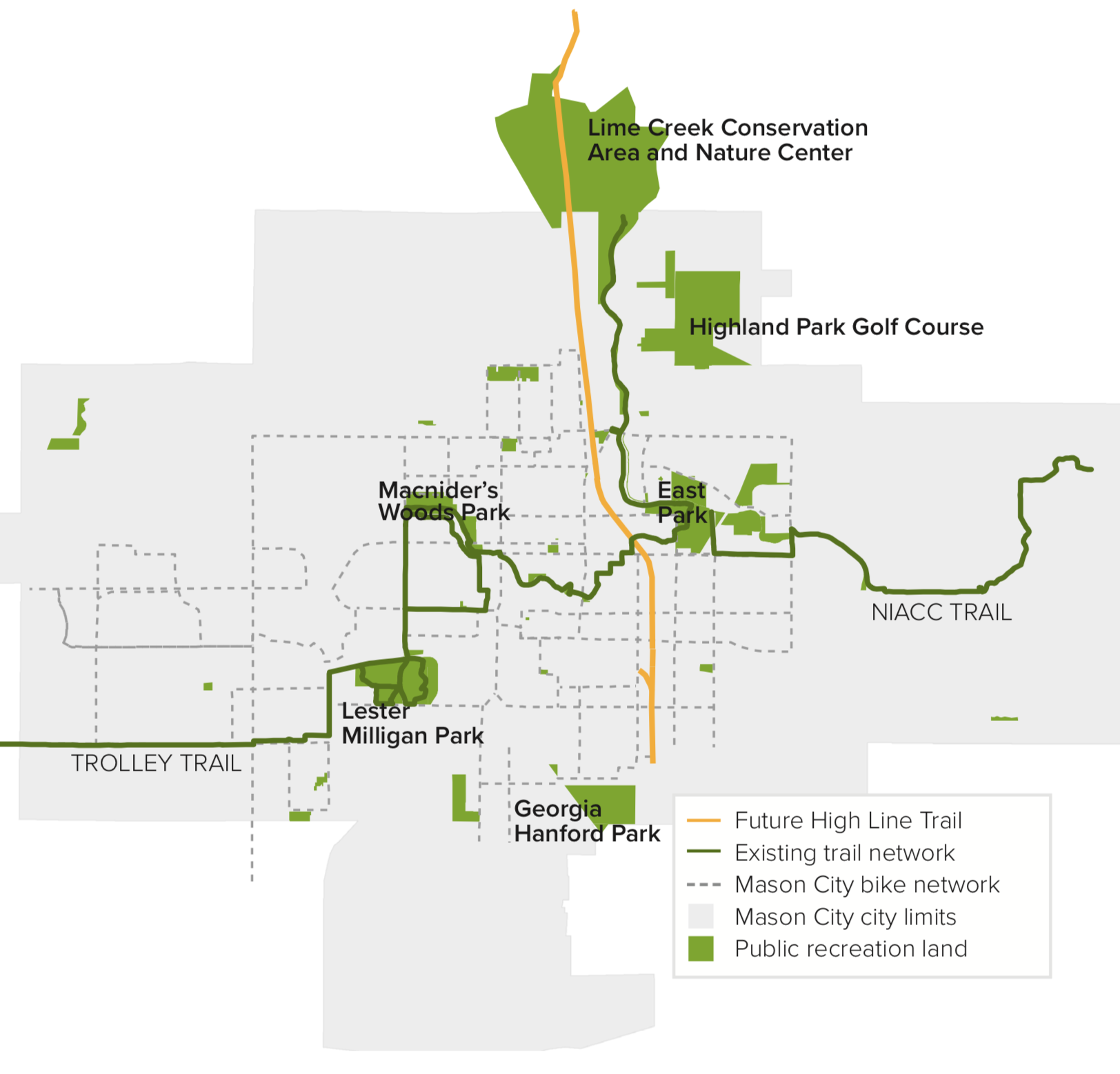
For years, Mason City has been a community passionate about public health and outdoor recreation, providing opportunities for active transportation and green space to its residents. Now, they have a new project to be excited about — an eight-mile, partially elevated multi-use trail zipping through the heart of the city.
The Blueprint
In 2012, Mason City was one of ten cities in Iowa selected to participate in the Blue Zones Project, an initiative designed to help cities and towns implement healthy choices into the routine of its residents. As part of the initiative, cities were encouraged to make changes in their communities that influenced health and wellness.
Immediately, Mason City knew it wanted to capitalize on the city’s already-flourishing biking community by creating a system that incorporated an active lifestyle into daily activities. They commissioned RDG Planning and Design, a Midwest-based company, to draw up plans for new bike routes and pedestrian spaces.
“One thing that really impressed us about Mason City was the number of people outdoors on a given day,” said Cory Scott of RDG. “It’s full of people walking around; it’s part of the culture, the DNA of the city, and that’s not something you see every day.”
As they drew up the plans, RDG took to the streets, covering Mason City on bikes to determine where and how people were navigating the city. They discovered that, while the city had several recreational trails, getting from one location to the next via active transit was challenging — many of the trails did not connect to points of interest around town.
“We looked at where people were wanting to go, and then developed a network of routes to get people from where they live to where they want to go,” said Marty Shukert, principal of RDG. “We wanted a destination-based model, connecting neighborhoods to key parts of the city — schools, businesses and recreational areas.”
The High Line
During this time, another exciting possibility presented itself. Two discontinued railroad routes running through the center of the city had the potential to be transformed into a multi-use trail. Much like New York’s famous High Line trail, the discontinued corridor features elevated railways, including one bridge around 100 feet wide, that could become a popular recreation area.
For years, Mason City leaders negotiated with the owners of the two rail companies to purchase the discontinued corridors. In 2016, the city reached out to INHF to help negotiate a purchase price and to assist in starting the federal process to buy the two corridors.
“A lot of times, these discontinued railroad corridors are the last areas in urban locations to find available green space,” says Andrea Boulton, INHF trails and greenways director. “Railroads often came before development, so these are some of the last places where we can find remnant prairie or wildlife habitat. Turning them into multi-use trails not only maintains the transportation use and enhances recreational opportunities, but also provides the city with a chance to reconstruct or steward the natural ecosystems there.”
One day, the unused railroads will become an eight-mile trail stretching through the city — joining the bicycle wayfinding system, bike and pedestrian lanes and 10 new bike routes Mason City implemented as part of the Blue Zones project. These connections offer not only recreational space for residents, but also an opportunity to engage visitors in the Mason City community.
“Trail use in Iowa continues to grow, and that can be a great opportunity to introduce people to a community,” Boulton says. “Having these multi-use trails provides free activities that are healthy and enjoyable, and it gives visitors a chance to see the community, explore the city and potentially realize they want to live there and invest in the community.”