INHF Flood Plain Outreach
By Taylor on August 22, 2013 in Blog
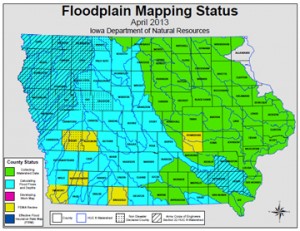
Image from Iowa DNR
This year, Iowa Natural Heritage Foundation started a flood plain outreach program. This new initiative coincides with the statewide flood plain mapping project of Iowa Department of Natural Resources and Iowa Flood Center.
Under the direction of Duane Sand, INHF public policy director, INHF will educate farmers and conservation groups to better understand local flood risks to farms.
According to the Iowa DNR, the flood plain mapping projects has potential to let Iowans know for the first time if their property is at risk from flooding. The maps will show the boundaries of flooded areas for the 1 percent annual chance (100-year) and 0.2 percent annual chance (500-year) floods.
Over the next five years, maps will be released to all 99 Iowa counties. In that time span, INHF is seeking grants to organize public information meetings statewide to explain the impact of these maps on conservation and effective farming practices.
For more information on flood plain mapping and the project's progress, visit http://www.inhf.org/flood-plain-outreach.cfm.